Relogging of the Butler Property Outcrops - Northern Ontario
Matthieu Cedou, Dominique Fournier, Thomas Campagne, Maria Soto Arrojo
Introduction
In mineral exploration projects, historical geological descriptions often remain an underutilized source of geological information, despite containing valuable observations recorded directly in the field. Text-based records, which are often variable in detail and structure, provide firsthand geological context on lithologies, structures, mineralization, and alteration.
Using Large Language Model applications (LLM) from Geoscience ANALYST Pro Geology, structured geological information can be extracted from poorly formatted descriptions. This approach models and organizes the geological information contained within the descriptions without relying on existing interpretive reports. This enables building an independent geological synthesis directly from historical field data, supporting exploration targeting and domain modelling workflows in a systematic, scalable manner.
This case study examines historical data from the Butler Property, made available by the Geological Survey of Ontario. The project is located in the Ring of Fire region of the James Bay Lowlands, Northern Ontario. The Butler dataset includes a total of 121 outcrop logs, each sample provided with a geographic location and a geological description. As illustrated in the Table 1, the descriptions vary greatly in quality: from (ACE geologist) detailed lithological, structural, and mineralization observations, to (LAX geologist) minimal and vague information.
Geologist |
Description |
Code |
|---|---|---|
ACE |
Small flat outcrop. Massive, fine-grained, grey-green magnetic siltstone to sandstone. Blebby cubic pyrite occurs along fracture planes. Cross cut by pegmatitic diorite trending at 020. |
S3c |
LAX |
sml o/c of cg anth alt’d rock (intrusive?) |
V |
This examplifies one of the key challenges associated with historical data compilation: the variability in the quality and detail of geological observations and field interpretation.
Note
This document demonstrates and assesses the capabilities of the Relog Descriptions and Summarize using LLM applications in Geoscience ANALYST Pro Geology. For the purpose of this evaluation, we use the application in single-pass mode, with no post-processing, manual corrections, or iterative refinements. We retain initial outputs exactly as generated to objectively evaluate the system’s baseline performance. This approach is intentional: our goal is to validate the applications under realistic, uncontrolled conditions. In operational settings, outputs would be subject to systematic quality control to ensure geological consistency and interpretive reliability.
Butler Property
As presented in Fig. 1 (A), the Butler Property alies within the Butler Assemblage (2,828 Ma) of the McFaulds Lake Greenstone Belt, part of the broader Ring of Fire region in Northern Ontario. It is located between the western and eastern limbs of a folded volcanic–intrusive sequence, bounded to the north by the Webequie Shear Zone and encompassing a large tonalitic core (~2,773 Ma) in its central–eastern portion (Downey et al., 2020), as shown in Fig. 1 (B).

Fig. 1 (A) Location of the Butler property in the Canada Greenstone Belt and (B) Geological map of the Butler property (Downey et al., 2020).
The property resides within a complex geodynamic (Downey et al., 2020) environment characterized by :
Mantle plume activity (~2,735 Ma) affecting the North Caribou microcontinent margin.
Extensive ultramafic sills and dykes (dunite, peridotite, pyroxenite, chromite) structurally above mafic–ultramafic conduit systems.
Varied sulfide deposits—including magmatic Ni–Cu–PGE and volcanogenic Massive Sulfide (VMS) systems formed along high-T volcanic and intrusive assemblages.
Regional deformation marked by isoclinal folds and dextral movement along the Webequie Shear Zone.
The Butler Property’s lithostratigraphy consists of:
Basal intrusive suite: ultramafic to ferrogabbro–gabbro cumulates forming layered intrusions.
Intermediate to felsic volcanic rocks: including tuffs, lapilli, breccias, and flows, hosting multiple VMS horizons.
Sedimentary and siliciclastic units interlayered with volcanic strata.
Capping ferrogabbroic sill showing igneous layering suggestive of east-dipping younging direction.
Hydrothermal alteration assemblages: biotite±anthophyllite–cordierite–chlorite–garnet zones within exhalative horizons.
In 2018, the exploration program comprised:
Relogging of historical drill core from Butler occurrences 1–10.
Geological outcrop mapping and sampling, targeting tonalitic intrusives, volcanic caprocks, and alteration zones (those outcrops are the one used in the present report).
Spatial synthesis to build a unified model of stratigraphy, intrusive architecture, alteration, and mineralization potential.
The combined core and surface data informed enhanced targeting and mineralization zoning across both Cu–Zn–Ag–Pb VMS occurrences (Butler 1–4) and Ni–Cu–PGE–Ti–V–Cr targets (Butler 5–8).
Note
The Butler report was used exclusively for validation and was not injected in any data processing, except for the Geological outcrop descriptions table used as input.
Applying LLM on Butler Property outcrops
Given the inherent complexity of the information provided in individual logs, we proceed with a three-level approach that gradually focuses the queries made to the LLM. The LLM used in the present case study is OpenAI o4-mini.
In the present case study, three LLM applications available in Geoscience ANALYST Pro Geology are used sequentially, as illustrated in Fig. 2. The role of this workflow is to extract structured geological information from unstructured outcrop descriptions, without relying on prior geological knowledge.

Fig. 2 The LLM applications used in the Butler property case study and their respective roles. These tools are applied sequentially to extract geological classes from outcrop descriptions.
Note
These applications integrate external LLM providers, either via remote APIs or local deployments, as part of a broader processing pipeline. As previously mentioned, the LLM used in this case study is OpenAI o4-mini.
Output quality and response time depend on the LLM model used and its configuration.
The privacy policies of external LLM providers are determined solely by those providers and are independent of this application.
Summarize
First, to have an overview of the present geology, we used the Summarize using LLM application. This application extracts information from descriptions and summarizes it. The interface is presented in Fig. 3.
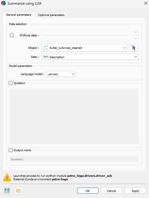
Fig. 3 Interface of the ‘Summarize using LLM’ application in Geoscience ANALYST Pro Geology. The application allows users to extract information from descriptions and summarize it using a LLM.
The summary provided by the LLM is the following (computing time: 44 seconds):
The mapped corridor exposes a polyphase mafic–intermediate–felsic magmatic pile with intercalated volcanic, volcaniclastic and sedimentary horizons, all overprinted by deformation, hydrothermal alteration and late‐glacial scouring.
1. Mafic Intrusive Complexes
 - NS–NE–trending bodies of coarse‐ to megacrystic gabbro–ferrogabbro–pyroxenite ± anorthosite.
 - Compositional (feldspar-rich vs. feldspar-poor) and modal layering tops to W–SE (dips ~30–48°/80°).
 - Ferrogabbro intergrowths host disseminated to massive magnetite (locally chalcopyrite blebs); coarse layers contain pyroxene phenocrysts and clots.
 - Late, fine-grained chlorite-altered gabbro pods and narrow tonalite–dacite sills cross-cut main masses.
2. Intermediate to Felsic Intrusives
 - Medium- to coarse-grained biotite-rich granodiorite–monzodiorite–tonalite bodies: massive to weakly foliated, non-magnetic, locally enclosing mafic xenoliths.
 - Aplite–pegmatite dykes (strikes ~270/090), quartz-feldspar diorite sills (020–055), and narrow aplite/quartz veins cross-cut all units.
3. Volcanic and Volcaniclastic Assemblages
 - Fine- to medium-grained flow-banded dacite–rhyolite (bedding ~078/80), locally porphyritic and amygdaloidal, cut by aplite dykes.
 - Thick lapilli- and ash-tuff packages, well foliated/crenulated (foliation ~240°), with chlorite–sericite–magnetite alteration.
 - Andesitic pillow lavas and flow breccias bearing chlorite–epidote–anthophyllite assemblages.
4. Sedimentary and Reworked Units
 - Very fine-grained, magnetic mafic siltstone/sandstone: bedding ~290°, north-up grading
locally massive. Cross-cut by medium- to coarse-grained diorite.
 - Interbeds of quartz arenite, mafic siltstone and felsic tuffs (bedding ~220–256/80), locally tightly folded.
5. High-Grade Metamorphic and Basement Rafts
 - Blocky felsic volcanic boulders (pink-grey flows) and coarse granite–granodiorite gneiss along river margins.
 - Possible migmatitic basement with mafic block rafts within dioritic bodies.
6. Structural Fabric, Alteration and Glacial Overprint
 - Regional foliations 005–238°, strong magnetite foliation at ~038/80. Discrete chlorite–carbonate–pyrite–quartz shear zones with quartz “ladder” veins.
 - Pervasive chloritization of mafic units
biotite–chlorite in gabbros, anthophyllite–chlorite in felsic flows
sericitization in tuffs.
 - Glacial striae on mafic and felsic outcrops oriented ~170–190°
Defining a proper benchmark for validating such a summary remains inherently difficult. Ideally, a geologist attempts the same task using only the outcrop descriptions to produce a comparable synthesis. However, this raises several challenges: (1) different geologists emphasize different aspects, and (2) determining which information to retain or discard involves subjective judgment and implicit thresholds. Despite these limitations, readers may still refer to the official report for comparison. However, it is important to note that the report’s geological summary does not rely solely on outcrop descriptions. It integrates additional data sources such as literature, drill core observations, and geophysical interpretations.
To compare the results of the summary, readers can refer to the geological context provided in the original report, available in the section geological setting of the Butler property.
Categorize
To extract information from the outcrop descriptions, the first step is to define which categories to target. This step uses the Question tool in the Summarize using LLM application, as illustrated in Fig. 4. Four distinct classes are defined: Lithology, Alterations, Minerals, and Texture. For each class, the prompt submitted is: What are precisely the present [class]?
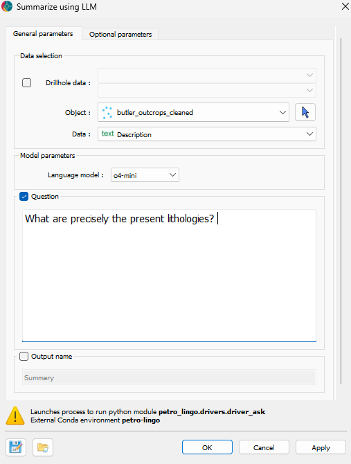
Fig. 4 Interface of the Summarize application and ‘Question’ tool in Geoscience ANALYST Pro Geology. The application allows users to ask questions to a LLM and retrieve answers.
The categories for each class retrieved by the model are presented in Table 2 (computing time for the lithology category: 1 minute and 12 seconds). The model identifies a total of 21 lithological categories, 5 alteration categories, 12 mineral categories, and 12 texture categories.
The application answers the questions in a structured way, as presented in the Table 2. The categories are organized hierarchically, with the main lithological classes (plutonic, volcanic, metasedimentary/metamorphic, and sedimentary) further subdivided into specific lithologies. Textures are also organized in a hierarchical manner.
To use this categories as input for the Relog Descriptions application, the structure of the table is removed and only the categories are kept. Moreover, some categories are manually removed before using them in the Relog Descriptions application. Those fields are in italic in the table.
Lithology |
Alterations |
Minerals |
Textures |
|---|---|---|---|
|
|
|
|
Relog Descriptions
The categories identified by the LLM are retrieved using the Relog Description application. The process is conducted in two steps.
Lithologies
First, as shown in Fig. 5, three lithological classes are extracted: Main lithology, Secondary lithology, and Third lithology—corresponding respectively to the dominant lithology observed in the outcrop and any additional lithologies present due to local intrusions or subordinate occurrences. A contextual prompt clarifies the hierarchical relationship between these categories. For each category, a confidence score reflects the model’s certainty regarding the relogged class. This score helps users identify results that may require closer examination, particularly in cases where the description is ambiguous or poorly structured.

Fig. 5 Interface of the ‘Relog Description’ application in Geoscience ANALYST Pro Geology for relogging lithologies. The application allows users to extract lithological information from geological descriptions using a LLM.
Alteration, Minerals, and Textures
Second, as presented in Fig. 6, the Relog Description application extracts the remaining three categories: Alterations, Minerals, and Textures. For this step, a multi-label approach applies. Since multiple minerals or alteration types can coexist at a given location, asking the LLM to assign a single label per category is not appropriate. Instead, the model is prompted to identify all categories explicitly present in each description.
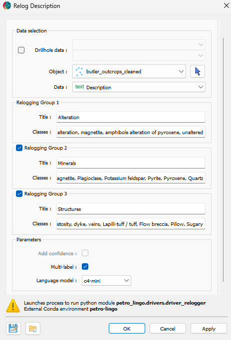
Fig. 6 Interface of the ‘Relog Description’ application in Geoscience ANALYST Pro Geology for relogging alterations, minerals, and textures. The application allows users to extract multiple geological features from descriptions using a LLM.
Results
The complete results are available in the Geoscience ANALYST workspace and in this spreadsheet. The following section presents an overview of the results obtained from the Relog Description application.
Main lithologies
For each of the 121 outcrops, a Main, Secondary, and Third lithology are assigned by the Relog Description application. A confidence score (low, medium, or high) is also assigned to each category (computing time: 41 seconds). The first rows of the results are presented in Table 3.
# |
Description |
Main Lithology |
Conf. |
Secondary Lithology |
Conf. |
Third Lithology |
Conf. |
|---|---|---|---|---|---|---|---|
1 |
mod sized o/c of fg dacite (locally amyg) and mcg anth-alt’d int flow |
Dacite |
high |
Andesite |
medium |
Unknown |
Unknown |
2 |
Old basement lithology? Migmatite shollen or raft texture. Mafic blocks with felsics squished out in between. |
Felsic gneiss |
low |
Unknown |
low |
Unknown |
Unknown |
3 |
smal o/c on W side of pond. combination of cg anth-alt’d volcanic & fg siliecous non-mag felsic tuff |
Felsic volcanic rock |
medium |
Felsic/intermediate tuff |
medium |
Unknown |
Unknown |
4 |
W edge of river, large blocky bldrs of fg pink-grey felsic volcn, possible flow txts |
Felsic volcanic rock |
medium |
Unknown |
Unknown |
Unknown |
Unknown |
5 |
sml o/c in river of strongly re-crystallized & slightly defomred flow-banded and in-situ bx’d dac/rhy. flow banding at 078/-80. unit cut by aplite dyke @ 040-/90. Looks like hunting camp here |
Dacite |
medium |
Granite |
medium |
Unknown |
Unknown |
6 |
4x4m flat bldr of str shr’d felsic volcanic with discrete chl-cct+/-pyr shears & qz ladder vns perp to shears (could this deform & veining be related to the WB shear?). 2 assays samples taken for gold (#130253, #130254) |
Felsic volcanic rock |
high |
Unknown |
low |
Unknown |
Unknown |
The results obtained are overall fairly accurate. As expected, the confidence scores are lower for the secondary and third lithologies, reflecting the model’s uncertainty when these are detected. The only notable misclassification in the sample set remains the assignment of “Granite” as a secondary lithology instead of the “Aplite” (description 5). This remains understandable given that the primary distinction between the two lies in grain size. Finally, the confidence score associated with the main lithology also highlights cases where the original descriptions are ambiguous or lack sufficient detail.
Multi-labels
For each 121 outcrops, alteration, minerals and structures has been detected by the application (computing time: 1 minute and 20 seconds).
The Table 4 presents a sample of the results for the alteration category . Overall, most alterations remain correctly identified. The LLM misses only one instance of garnet alteration, embedded in the phrase “med sized o/c of chl-gt alt’d schist” in description 11. Additionally, magnetite (noted as “mag” in the descriptions) is not mapped as magnetite alteration. This omission remains justifiable, as the presence of magnetite is not necessarily indicative of alteration. It can be primary, particularly in magnetite-bearing lithologies such as ferrogabbro.
# |
Description |
Amphibole |
Anthophyllite |
Chloritization |
Garnet |
Magnetite |
|---|---|---|---|---|---|---|
7 |
Medium to coarse grained, massive, white-grey anorthositic gabbro. Pyroxene clots protrude from the surface with plagioclase recessively weathered. Pyroxene appears partially altered to amphibole. |
X |
||||
8 |
Medium to coarse grained, massive, white-grey anorthositic gabbro. Pyroxene clots protrude from the surface with plagioclase recessively weathered. Pyroxene appears partially altered to amphibole. |
X |
||||
9 |
med sized o/c of chl-gt alt’d schist & mcg anth alt’d int flow(?), w-mod mag |
X |
X |
|||
10 |
v.lg smoothed o/c of v.d.green fg non-basalt, possible flow bx txt locally. glacial striae @ 170. pervasive chl altn |
X |
||||
11 |
sml o/c W of lake, str anth alt’d volcanic (unknown protolith but likely int/felsic flow). v.wk mag. minor qz veins (10–20 cm) trending 180/-90 or 054/-65. |
X |
||||
12 |
lg flat o/c of fmg highly siliceous weakly fol’d non-mag felsic sandstone or dacite/hypabyssal intrusive. Compositionally very uniform, no obvious bedding. Weathered surface is granular (quartz > feldspar). No significant alteration. Glacial striae @ 180. |
Misclassified Lithologies
The lithological results generated by the LLM have been compared to the original lithologies logged by geologists. To enable this comparison, the lithology classes identified by the LLM were mapped to those used by the geologists. Further details can be found in the Litho_code tab of the spreadsheet.
Fig. 7 presents a pie chart comparing the main lithologies identified by the Relog Description application with those recorded during field logging.

Fig. 7 Quantitative comparison of the primary lithology identified by the Relog Description application and that logged in the field. (1) Pie chart showing the proportion of matching vs. non-matching results; (2) Pie chart showing a manual reclassification of the mismatched cases.
Before comparing the results, it must be noted that the lithologies assigned by geologists in the field and the descriptions can be complementary. Moreover, due to the interpretative nature of lithological classification reflecting a natural continuum rather than discrete categories, differences in terminology may arise. In the following exercise, the lithologies identified by both the LLM and the geologists are compared solely based on the logged descriptions.
The mismatched lithologies were manually reviewed and classified according to the nature of the discrepancy. The classification categories are as follows:
Closer: The LLM-assigned lithology differs from the field-logged lithology but provides a better match to the logged description.
Close: The LLM-assigned lithology is not identical to the field-logged one but is reasonably consistent with the description.
Not precise: The description is too vague to confidently assign a precise lithology.
Overall, 68% of the main lithologies assigned by the LLM match those logged in the field. Among the 32% of mismatches, 61% are classified as “Closer,” 34% as “Close,” and 5% as “Not precise”. Notably, in the present application, the LLM never assigns a lithology that is entirely inconsistent with the logged description. The Table 5 presents examples of mismatched lithologies for each of the three categories.
Description |
Geologist Lithology |
LLM Lithology |
|---|---|---|
Closer |
||
Medium grained, massive, white, grey, green diorite to leucogabbro. Non-Magnetic. Knobby texture. |
Anorthosite |
Diorite |
Massive, fg, grey-green magnetic siltstone to sandstone. Strongly foliated at 005. Cross cut by mg diorite parallel to foliation. |
Mudstone |
Siltstone |
Close |
||
lg N-S ridge of felsic lap-tuff & lesser cg anth alt’d int flow. non-mag. locally abundant amyg patches and fragments |
Felsic volcanic rock |
Felsic/intermediate tuff |
sml bldr field of lg angular mcg fpr-proph tonalit/diorite with rare bldrs of flow-banded dac/rhy. first appearance of volcanics, intrusives are porph |
Microtonalite |
Diorite |
Not precise |
||
v.lg smoothed o/c of v.d.green fg non-basalt, possible flow bx txt locally. glacial straie @ 170. pervasiev chl altn |
Basalt |
Chlorite-schist |
sml o/c W of lake, str anth alt’d volcanic (unknown protolith but likely int/felsic flow0. v.wk mag. minor qz veins 910-20cm) trending 180/-90 or 054/-65. |
Unknown |
Dacite |
Spatial interpretation
Once the outcrops are relogged, they can be used for geological interpretation. This section provides an example of how the relogged outcrop descriptions can be applied; in this case, to identify prospective targets.
The Relog Description application assigns geological values to each point representing an outcrop. To visualize the spatial distribution of these values and identify potential trends, the points are interpolated onto a 2D grid using both Neural Kriging and 2D Grid Domains Segmentation applications available in Geoscience ANALYST Pro Geology.
Lithologies
Once relogged, the lithology is interpolated using the 2D Grid Domains Segmentation application, propagating the lithologies using the magnetic data, as shown in Fig. 8. Although the spatially uneven distribution of outcrops limits the accuracy of geological interpolation, this representation provides a useful overview of the regional distribution of geological units.
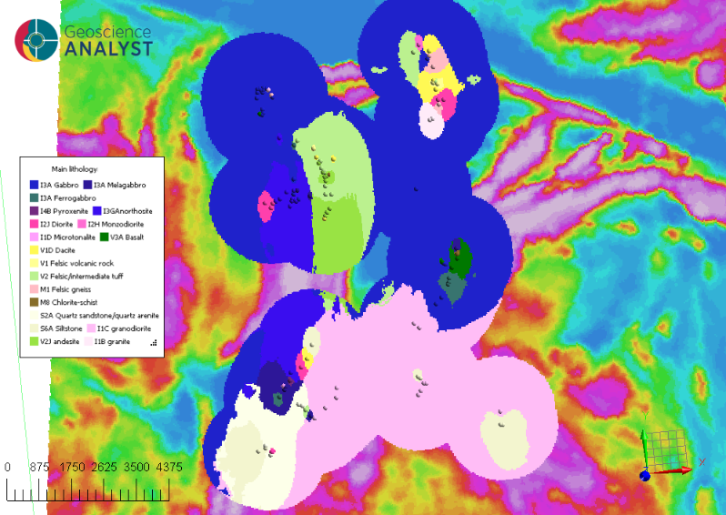
Fig. 8 Spatial propagation of the main lithologies identified by the Relog Description application on the Butler property; magnetic data used as secondary data during interpolation is projected in the background.
The interpolated lithologies show, from South to North, a sequence consisting of sedimentary clastic rocks, a major granodioritic intrusion, followed by mafic intrusive rocks. The presence of intermediate to felsic volcanic rocks along the northern and western edges of the triangular zone is defined by positive magnetic anomalies.
Prospective targets
To define prospective areas, the presence of anthophyllite, chlorite, and garnet alterations, as well as veining, is interpolated using the Neural Kriging application. The Fig. 9 illustrates the results of this interpolation. These interpolations highlight two zones of interest shown in Fig. 9: (1) to the north and (2) to the west of a triangular-shaped magnetic low anomaly, bounded by linear positive magnetic anomalies at the center of the property. These alteration anomalies are spatially correlated with the felsic and intermediate volcanic rocks interpolated in the previous section. On the southeastern flank of this magnetic anomaly, chalcopyrite was observed in an outcrop (3), in association with basalt and ferrogabbro.

Fig. 9 Interpolated presences of anthophyllite, chlorite, garnet, and veining define prospecting targets; an outcrop with chalcopyrite is also projected; magnetic data is projected as background
The presence of veining, chloritization, and intermediate volcanic rocks (dacite) in the northern target (1) area may indicate a hydrothermal system consistent with an exhalative mineralization environment (Ross et al., 2019), possibly represents a distal VMS setting. In the western target (2), the combination of anthophyllite, chlorite, and garnet alteration within intermediate volcanics suggests a more proximal hydrothermal zone (Hokka, 2020), potentially closer to the feeder system. Lastly, the occurrence of chalcopyrite associated with basalts and ferrogabbro on the southeastern flank (3) may represent a distinct mineralization style, likely magmatic-hydrothermal origin (Namur et al., 2012).
Prospectivity targets validation
The Fig. 10 presents the targets identified in the 2018 report. Comparing with the targets inferred from surficial outcrop descriptions alone, a correspondence is observed with Butler 1-2 with target 1, Butler 3 with target 2, and Butler 6 with target 3. Butler 1 and Butler 3 are related to exhalative horizons, while Butler 6 is associated with remobilized or hydrothermal sulfides at the contact between ferrogabbro and tonalite intrusions (Downey et al., 2020). Those observations remain similar to the ones obtained with the LLM using outcrop descriptions only.
Following manual inspection of the outcrop descriptions, no supporting evidence emerges for the remaining targets listed in the original report, as they were targeted and identified through drill core observations and geophysical data.

Fig. 10 Targets defined during the 2018 drill core relogging and geological mapping campaign on the Butler property; previously found targets are projected on the map.
Discussion
This study demonstrates that LLMs can extract structured geological information from historical outcrop descriptions, even when the text is inconsistent or incomplete. By applying engineered LLM application, key attributes such as lithology, alteration, minerals, and texture are retrieved. The inclusion of a confidence score provides a practical measure of reliability, allowing users to identify uncertain outputs. Based on precise descriptions, it enables the extraction of accurate categories, making it easier to fully leverage field information during office interpretation and reporting.
Once relogged, the extracted data are interpolated spatially using 2D Grid Domains Segmentation and Neural Kriging. This approach allows the construction of a preliminary geological model directly from descriptive text. The identified targets show spatial correlation with known exploration zones (e.g., Butler 1, 3, and 6), supporting the relevance of the method in early-stage interpretation, particularly in historical datasets.
However, the LLM’s performance strongly depends on the quality of the input descriptions. Incomplete, vague, or poorly structured observations lead to inconsistent outputs; similar to the limitations faced by human interpreters. LLM outputs reaffirm a long-standing truth: the quality of geological interpretation -manual or automated- can only match the quality of the original field descriptions. When encountering an outcrop, the best investment remains a clear, detailed, and objective description.
Conclusion
Geology is a naturalistic science, grounded in the direct observation and description of rocks and their relationships. To simplify spatial interpretation and enable digital workflows, these observations are often reduced to categorical fields, introducing a degree of interpretation and losing part of the original information. Selecting a lithology name, for instance, is a subjective decision.
Yet, while classifications may shift over time, precise, factual observations remain stable and valuable. With LLMs, geologists can easily re-inject these observations into their workflow more effectively, transforming descriptive text into adaptative structured inputs for modelling and targeting. This unlocks the full potential of historical records and their associated descriptions.
Geologist |
Description |
Code |
|---|---|---|
ACE |
Small flat outcrop. Massive, fine-grained, grey-green magnetic siltstone to sandstone. Blebby cubic pyrite occurs along fracture planes. Cross cut by pegmatitic diorite trending at 020. |
S3c |
LAX |
sml o/c of cg anth alt’d rock (intrusive?) |
V |
Ultimately, as illustrated in the table above, the success of LLMs in geology is not solely about the algorithms or models used, but rather about the quality of the geological fieldwork and observations. Accurate, objective, and detailed descriptions are essential for effective interpretation and modelling. So, as geologists, don’t be LAX, be ACE.